In 1963, the Army Corps of Engineers dredged 231,000 cubic yards of nearshore sand to expand the Port Townsend Boat Haven and dumped it into what had been a beautiful, tidally flushed estuary called …
This item is available in full to subscribers.
We have recently launched a new and improved website. To continue reading, you will need to either log into your subscriber account, or purchase a new subscription.
If you had an active account on our previous website, then you have an account here. Simply reset your password to regain access to your account.
If you did not have an account on our previous website, but are a current print subscriber, click here to set up your website account.
Otherwise, click here to view your options for subscribing.
* Having trouble? Call our circulation department at 360-385-2900, or email our support.
Please log in to continue |
|
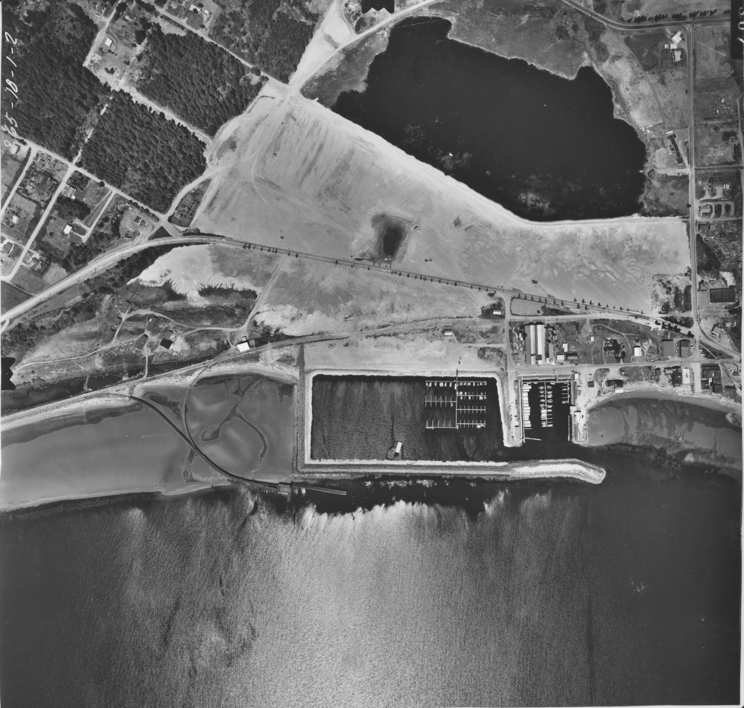
In 1963, the Army Corps of Engineers dredged 231,000 cubic yards of nearshore sand to expand the Port Townsend Boat Haven and dumped it into what had been a beautiful, tidally flushed estuary called Kah Tai (qatáy) Lagoon.
Dumping the sand offshore was deemed too expensive, and the 1960s logic was that estuaries weren’t important anyway. As a part of making the dumping more palatable, rows of Lombardy poplars were planted along the highway. The species was selected more for availability, low cost, and speed of growth than for any benefit to the area.
The Port of Port Townsend had acquired most parcels in the lagoon prior to dumping, and the intent was to build a strip mall on the sand after letting both the sand and the public outrage settle for a few years. Downtown businesses raised a 1,000-plus signature petition against the strip mall idea, arguing that such a development could bankrupt them. A series of lawsuits by citizens delayed the strip mall effort, while a parallel effort by volunteers led to the submission of a grant proposal in 1980 to the National Park Service to make the area a Land and Water Conservation-funded nature park. The city had no money for matching, so the grant match consisted of generous donations of a few privately owned parcels of land that the port had not managed to purchase. The county and port both agreed to give their land in the area to the city if the grant was funded.
The LWCF grant was funded in 1981 and the park boundary established. A second grant proposal to the state provided for the start of development and a 1986 landscape plan was generated by well respected landscape architects and reviewed favorably by a rather famous ornithologist. That plan included a layout of the park into zones with appropriate plant species.
The plan for the zone along Sims Way included: Year 1, remove all poplar seedlings and some mature poplars and plant natives; Year 3, remove more poplars, plant more natives; Year 10, remove more poplars to establish view corridors. The port didn’t sign over its Kah Tai holdings to the city in a timely way, so a 30-year lease was signed in 1982 to allow sufficient time to complete the transfer.
Unfortunately, the full plan was ignored and no land transfer occurred in the 1980s or 1990s or 2000s. Instead, all official effort to follow the landscape plan was halted, but time, volunteers and birds continued to plant.
If you lived here in the 1980s, you may well have been one of the volunteers who planted natives along Sims, behind the poplars. The beautiful natives filled in the corridor but the poplars remained, a wall of trunks blocking the view and limiting the growth of the native species. A final lawsuit in 2011 led to completion of the land transfer in 2014.
You cannot see the Western Larch turning gold in the Kah Tai woodland because the poplars block the view. You cannot see the beautiful Monterey Cypress (regionally appropriate but not native) or the Douglas firs, Shore Pines, Western Red Cedar, Madrone, the young junipers, Western White Pine, serviceberry, and numerous understory species along Sims because of the poplars. Our native poplars (cottonwoods) are long-lived, but Lombardy poplars are short-lived, brittle, too vertical for most bird species to use, with shallow, spreading, invasive roots.
On the port side of Sims, the poplars do more than block the view. They wander around the property line so that some are on city right of way and some are on port property. Their proximity to high voltage lines and boat masts make them dangerous.
The PUD needs to underground those power lines on the city right of way, but the shallow, invasive roots make that impossible. The port owns nearly an acre of land that is currently unavailable for economic development because of the poplars. The port has every right to utilize its property and we have a wealth of local professional arborists willing to follow our municipal code on trees and collaborate to advise about selecting appropriate replacement species.
If you want to know some species that will grow on the south side of Sims, look across the highway. Diverse native species are already here again, and thriving. Let’s do it right this time, on both sides of the Sims Way corridor.
Note: The opinions expressed here belong to the author. An article about Kah Tai written for The Leader in 1984 by then-parks superintendent Kevin Burke provides much more detail about the history, and can be read at http://kahtai.blogspot.com/p/park-emerges.html.
(Deborah B. Jahnke is chair of the Port Townsend Parks, Recreation, Trees and Trails Advisory Board.)


